The other day I had a little chat with one of my IVAO controller friends. Somehow we came to the difference how Microsoft Flight Simulator and X-Plane simulate the reception ranges of localizers. I said that when I fly with X-Plane on a typical IFR downwind abeam field I do not receive anything from the localizer, i.e. I have that “red nav flag” in my VOR gauge and couldn’t even ident the morse code. That’s very different to Flight Simulator: On FS you can often ident the localizer while you are just starting the initial approach or even when on arrival. My fellow said, that in real life you should typically be able to reliably receive the localizer inside a sector of 40 degrees to the left and to the right of the runway center line. I felt that this is about what I see simulated on X-Plane, but until today I had no idea how this is really done…
Let’s take runway 27 of Bremen airport (EDDW) as an example. How is the operational (usable) range of the localizer specified? There is a table of radio navigation aids in the AIP:
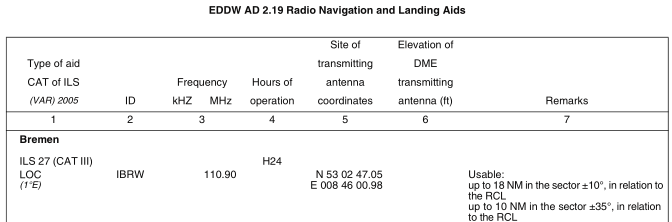
The specification says +/– 35 degrees in relation to the RCL. Taking into account that reception and operational reception are different matters, my fellow was spot on. But how is the differentiation between the reception ranges of the 35 degrees sector (10 nautical miles) versus the 10 degrees sector (18 nautical miles) modeled and are there even ways to model different reception characterists per each localizer?
Let’s have a look into the file that defines radio navigation aids. X-Plane uses a plain text file called earth_nav.dat as a repository for this kind of data (uhmmm, yes dear FS lovers, it is that easy to mess with navaids on X-Plane…). A quick search in that file for Bremen’s localizer for runway 27 gets us this line (header line added by me):
#  lat          lon             elv freq   range  bearing idnt aprt rwy name
4  53.04640300  008.76694200    14  11090  18     267.872 IBRW EDDW 27  ILS-cat-III
What do these columns mean? Let’s have a look into X-Plane’s Navdata Spec (pdf) for the nav data type localizer (code 4):
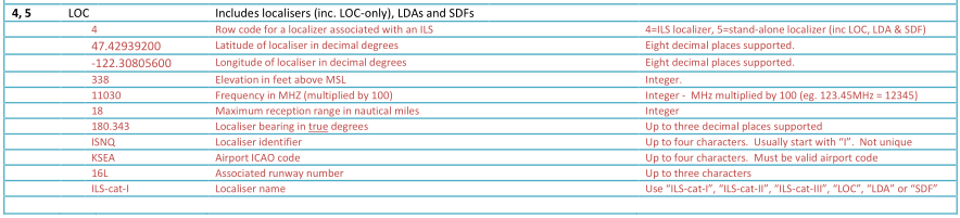
The sixth column describes the “Maximum range in nautical miles” and column seven the “Localizer bearing in true degrees”. Does the range 18 NM of IBRW seem familiar? Yes, that’s what is specified in the AIP above. Probably the AIP is the origin of a lot of X-Plane’s data; you can observe throughout the whole navaid file that the specs there match exactly what is officially published. Except for the lateral position and elevation this is all you can individualize about the reception sphere of localizers. That means, X-Plane must have one generic model that’s applied globally to localizers.
How does this model look like? I did not find anything on the interwebs, so I figured, let’s do some virtual empirics. X-Plane has a simple map feature, with which you can position your aircraft anywhere in the air. Another nice feature of X-Plane’s map is, that you can click on any navaid or intersection and the map shows your radial and distance in relation to that point. I’ve tuned Bremen’s localizer runway 27 (IBRW) into NAV1 and did some drag and drop. It turns out, that I lose LOC reception consistently on a radial of 117 degrees magnetic of the localizer on any distance from 3 NM and 22.6 NM. I did not test under 3 NM and further away than 22.6 NM there is no reception at all.
Reciprocal of 267 is 087, that makes 30 degrees to the radial of 117. That means the localizer reception sector is +/– 30 degrees from runway center line and extends the “usable range” by 4.6 NM.
Let’s take another example: KLAX 25L. X-Plane’s definition of the localizer is:
#  lat         lon              elv freq   range  bearing idnt aprt rwy name
4  33.93329900 -118.42247700    117 10990  70     262.925 ILAX KLAX 25L ILS-cat-III
Localizer course is 251 degrees magnetic (according to the chart). And yes, 70 NM is quite a reach for a localizer. Have a look at the published procedures and you know why… The drag and drop map fun delivers a consistent border radial of 099 degrees magnetic in relation to the localizer from 10 NM up to 87.7 NM. Wait a second… 251 reciprocal is 071 … that makes 28 degrees. That’s odd, isn’t it?
Let’s have a look at the runway information on skyvector. The runway heading is 263 degrees true. That’s fine, that’s in X-Plane’s navdata—but the magnetic heading of the runway is 249. There are our missing 2 degrees, we’ve spot an error! The localizer has an offset of 2 degrees to the runway heading, but it doesn’t have that in X-Plane. Ok, it’s a tiny error, but we’re getting somewhere.
KLAX localizer range exceeds the (in X-Plane) specified range by 17.7 NM. Maybe there is some multiplier? I don’t know, to me this is enough research for today.
The next time we’re on radar vectors downwind abeam field we know why we can’t identify the ILS. And now we know, that when we’re on the RIIVR TWO Arrival inbound KLAX we should be able to receive the LOC as early as at GRAMM or even earlier, which is about in the middle of the STAR.
Have fun!